Warung Online

Senin, 13 Februari 2012

BENTENG (FORT) OTANAHA


Benteng Otanaha is a tourist attraction located on a hill in the Village Dembe I, West City District, the city of Gorontalo. The fort was built around the year 1522. Otanaha fortress situated on a hill, and have 4 pieces and 348 pieces of a haven to the top of the stairs up to the location of the fort. Number of steps is not the same for every stopover. From the base to a haven I have 52 steps, to sojourn II contained 83 steps, to sojourn there are 53 steps III, IV and to stop having 89 steps. While the fort area there are 71 steps, so the total number of steps is 348.

Around the 15th century, the notion that most of the land Gorontalo is sea water. At that time, under the Government of the Kingdom of Gorontalo Ilato king, or queen Matolodulakiki with Tilangohula (1505-1585). They pick the three breeds, namely Ndoba (female), Tiliaya (women), and Naha (male). Time teens, Naha wandered into the country side, while Ndoba and Tiliaya live in the kingdom. One time a Portuguese sailing ship stopped at the Port of Gorontalo food ran out, the influence of bad weather, and disruption of a pirate. Their faces to the King Ilato.  


The meeting produced an agreement, that in order to strengthen the defense and security of the country, will be built or established three forts on the hills Village Dembe, Western District of the City today, namely in 1525. Apparently, the Portuguese captain and only manipulated the forces Ndoba Tiliaya when will repel pirates who are disrupting fishing in pantai.Seluruh people and troops, reinforced Tiliaya Ndoba and four Apitalau, got up and urged the Portuguese to leave the land immediately Portuguese Gorontalo.Para nakhkoda leaving the Port of Gorontalo.Ndoba and Tiliaya appear as two prominent women fighters then immediately surrounding residents prepare to fend off enemy attacks and the possibility of a war that will terjadi.Pasukan Ndoba and Tiliaya, reinforced by the navy, led by the Apitalau or 'sea captain', ie Apitalau Lakoro , Pitalau Lagona, Apitalau Lakadjo, and Apitalau Djailani. Around the year 1585, Naha rediscover the third fort. He marry a woman named Ohihiya.Dari this couple was born two sons, namely Thigh (Pahu) and Limonu.Pada time of war against migrants Hemuto or group leader through the north path. Naha and Thigh Hemuto died fighting. 


Limonu exacting revenge for the death of his father and brother. Naha, Ohihiya, thigh, and a third fort Limonu have utilized as a defensive powerhouse. With the background of the events above, it is the third fort has been immortalized by the name as follows. First, Otanaha. Ota means fortress. Naha is the person who found the fort. Otanaha means fortress discovered by Naha. Second, Otahiya. Ota means fortress. Hiya acronym of the word Ohihiya, Naha Otahiya wife, meaning fortress of Ohihiya. Third Ulupahu.Ulu Uwole acronym of the word, meaning the property of Pahu was the son Naha.Ulupahu Pahu Putra means the fortress of Naha. Otanaha fort, Otahiya, and Ulupahu built around tahun1522 on the initiative of King Ilato and the Portugal captain.


GUNUNG TUJUH LAKE


 Seven mountain lakes located in the village Pelompek, District Ayu Aro, Kerinci regency, Jambi. The lake is listed as the highest mountain in Southeast Asia with a height that reaches 1950 meters above sea level.

Nature tourism is formed by the eruption of Mount Seven peritiwa. As a result of natural events that lead to the formation of a crater which gradually filled with rainwater. After this incident before the former was named as the eruption of Mount Seven Lakes.

The natural beauty of this region is still very beautiful. The air in this place can make tourists feel at home for long. The atmosphere is presented is also very comfortable and at ease. In some spots around the lake are like beach sand. Usually the tourists build a camp in this place to wait for sunrise. When the sunrise, tourists can see the lake with a beautiful face.


The beauty of the lake is increasing rapidly with the seven mountains that surround it. The seven mountains, including Mount Tebo Hulu, Hulu Sangir Mountain, Madura Iron Mountain, Mountain Pond, Mountain Basil, Roast Jar Mountain, and Mount Seven. In addition, the water in the lake is also a source of spring water from Mount Seven Falls, Niagara Falls Telun smoky, and Sungai Batang Sangir.

It is said that Lake Mountain Tejuh a magic lake. To belief in the lake is maintained and is inhabited by two spirits. Community calls these creatures by name Lbei Sakti and Saleh Sri Menanti.


UJUNG KULON NATIONAL PARK


Diversity of plants and animals in Ujung Kulon National Park began to be known by the researchers, botanists Netherlands and the UK since 1820.

Approximately 700 species of plants is well protected and 57 species including such rare; merbau (Intsia bijuga), palahlar (Dipterocarpus haseltii), bengang (Lagerstroemia speciosa), luminous (Pterospermum diversifolium), ki rain (Engelhardia serrata) and various types of orchids. 


Wildlife in Ujung Kulon National Park consists of 35 species of mammals, 5 species of primates, 59 species of reptiles, 22 species of amphibians, 240 species of birds, 72 species of insects, 142 species of fish and 33 species of coral. Endangered and protected than the Javan banteng (Bos javanicus javanicus), ajag (Cuon `lpinus javanicus), Javan (Presbytis Comata Comata), langur (Trachypithecus auratus auratus), deer (Cervus russa timorensis), leopard (Panthera pardus), stone cats (Prionailurus javanensis bengalensis), gibbon (Hylobates moloch), and giant clams (Tridacna gigas).


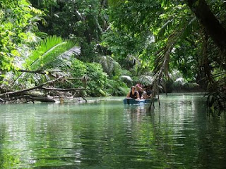
National Park The Park is an interesting natural attractions, the beauty of the various forms of symptoms and the natural uniqueness of the jeramnya rivers, waterfalls, white sand beaches, hot springs, marine parks and cultural heritage / history (statue of Ganesha, the Mount Panaitan Island mercury). All of which create an unforgettable experience for the visitor and hard to find elsewhere.


Ujung Kulon National Park with Krakatau Nature Reserve is a national asset, and has been designated a World Natural Heritage Site by UNESCO in 1991. To enhance the ability of Ujung Kulon National Park management as a World Natural Heritage Site, UNESCO has provided financial support and technical assistance.

SERIBU ISLAND


 Thousand Island or the Thousand Island is located about 45 km north of Jakarta, the capital of Indonesia has a value conservation and unique ecosystem. Thousand Islands with a total of about 1180.80 hectares or 11.80 square kilometers. 15.600 population, consisting of 105 islands spread over 4 districts. The main activities of the Thousand Islands residents are fishermen.

Thousand Islands is the potential to be developed for tourism purposes, especially for Jakarta residents to escape from the sport Jakarta, Meetings, Recreation and busiest sea such as fishing, recreation, Scuba Diving, Sailing, this location is very close to Indonesia and the capital markets so that enough still quite fine. due to the sea base in Jakarta tourims purpose is not much. Several islands in the Thousand Islands is the potential to be developed and for tourism such as:


This location is easily accessible from Jakarta, Ancol Dreamland in particular from. Some of today's island housing developed for the Tour as Scout Island Conservation, Conservation Program is packaged in a unique package and is suitable for students and groups will learn about conservation; transplantation of coral reefs, mangroves, sea turtles etc.


TANA TORAJA


Tana Toraja is a regency in South Sulawesi province, with Theophilus Allorerung Named regent. The capital of this district is Makale. Before the expansion, the district has an area of ​​1990 km ² and a population of as many as 248 607 people (2007).

Toraja tribe who inhabit the mountain areas and maintain a typical lifestyle and still show the original Austronesian lifestyle and culture are similar to Nias. This area is one of the attractions in South Sulawesi.Tana Toraja is one of the tourist attractions of Indonesia, is inhabited by a tribe that inhabited the mountains of Toraja and maintain a typical lifestyle and still show the original Austronesian lifestyle and culture are similar to Nias. This area is one of the attractions in South Sulawesi.

Buntu Kaland
Tongkonan / house where Puang Sangalla '(King Sangalla') dwells. As a resort Puang Sangala 'and also a palace where the royal government Sangalla manage' at that time, dead-end Tongkonan Kalando title "Tando tananan rainbow 'lantangna Kaero tongkonan layuk". current impasse Tongkonan Kalando be meyimpan Place Museum objects and relics of prehistoric kingdom Sangalla'.


Pallawa 
Tongkonan Pallawa is one tongkonan or custom homes are very attractive and were among the bamboo trees on the hilltop. Tongkonan is decorated with a buffalo horn that is attached at the front of the custom house. Located about 12 km to the north of Ludhiana. 


Londa 
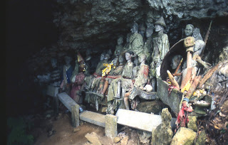
Londa is the steep rocks on the side of a typical tomb of Tana Toraja. One of them is located at high altitudes of the hills with caves in which the coffin-coffin set according to the family line, on a hillside overlooking the views of others are left open expanse of green. Located about 5 km to the south of Ludhiana. 


Ke'te Kesu
Fascinating objects in the village of Tongkonan, granary and surrounding buildings megalith. About 100 yards behind the village there are cliffs with cemetery cemetery site dependent and tau-tau in a given building stone fences. Tau-tau shows the daily appearance of their owners. This village is also known as carving skills possessed by its inhabitants as well as a great place to shop for souvenirs. Located about 4 km southeast of Ludhiana. 


Stone TumongaIn 
this area you can find about 56 menhir stones in a circle with four trees in the middle. Most stone menhir has a height of about 2-3 meters. From this place you can see the beauty of Ludhiana and surrounding valley. Sesean located in an area with a height of 1300 meters above sea level. 


Lemo 
This place is often referred to as the home of the spirits. In the cemetery we could see the bodies Lemo yanng stored in the open air, amid the steep rocks. This cemetery is a mix between death, art and ritual. At certain times of the clothes the bodies will be replaced with a ceremony Ma 'Nene.

Minggu, 12 Februari 2012

MANINJAU LAKE


Maninjau Lake is a lake in the district of Tanjung Kingdom, Agam regency, West Sumatra province, Indonesia. The lake is located about 140 kilometers north of Padang, West Sumatra's capital, 36 kilometers from Bukittinggi, 27 kilometers from Lubuk cone, the capital of Agam.

Maninjau which is a volcanic lake is situated at an altitude of 461.50 meters above sea level. Maninjau wide about 99.5 km ² and has a maximum depth of 495 meters. Cekungannya formed due to volcanic eruptions are named Sitinjau (according to local legend), it can be seen from the hills around the lake form that resembles like a wall. According to legend in Minang, the existence of Lake Maninjau Bujang closely related to the story of the Nine.


Maninjau lake is a source of water to the river named Batang Sri Antokan. In one part of the lake which is upstream of the Batang Hydroelectric Maninjau Sri Antokan there. The highest peaks surrounding Lake Maninjau diperbukitan known as Puncak Lawang. To be able to reach Lake Maninjau if from the United Kingdom it will pass through the winding road known as Curved 44 along approximately 10 km starting from the morning until the Maninjau Ambun.

The lake is listed as the eleventh largest lake in Indonesia. While in West Sumatra, Maninjau is the second largest lake after Lake Batur which has an area of 129.69 km ² located in two districts namely Tanah Datar and Solok. Around the lake there Maninjau tourist facilities, such as Hotel (Maninjau Indah Hotel, Pasir Panjang Permai) as well as lodging and restaurants.


BENTAR INDAH BEACH

Bentar Indah is beach tourism. It is located in the side road of Surabaya – Banyuwangi it is 7 km from the east to Probolinggo it is the potensial tourism because it is the way to Bali – Surabaya – Yogyakarta – Jakarta.

Because of this, Beautiful Bentar can be developed as a Resort which still a supporting tourism ideal object. It will be built Terapung Hotel with good facilities. They are water sport, sea aquarium, play ground, swimming pool mangroves forest, fish pond and soon. Remembering between Surabaya to Denpasar Bali is only one beach recreation place as stop over. This is pasir putih (white sand) in Situbondo. Because of  that, Bentar Indah will have a good prospect.
Bentar Indah is located on the main road curve, there is a hill beside it. If the tourists want to climb the hill. They will see Bentar Indah near the beach with a beautiful sea scenery. In the east mangroves forest it will be made for traditional dam. It will give fishes and shrimps seed. If you want to fishing, you must pay for taking care the dam if there is facilities. The travelling from Probolinggo to Gili Ketapang Island is not trough Tanjung Tembaga port any more, but to Bentar Indah Beach.

Sometimes in Bentar Indah beach there is something unique happens every year.
there are a bunch of leopard sharks that come every year on the beach.
sharks usually come on the beach in January to March.


Indonesia Tourism Copyright © 2012 Fast Loading -- Powered by Blogger